

About 4 weeks ago I decided that I needed to get back into a sport which I competed in when I was a teenager. Part of this decision came from wanting to get out in the open air more, but also as my fitness is improving through doing Parkrun each week I felt that I needed a way of developing this without the need of going down a sweaty gym or just pounding the streets without much of a goal. Yes, Strava helps with segments set along the roads (other mobile apps are available). However I find myself running the same route over and over again. Doing this I just loose interest. Partly why I visit different Parkruns I guess.
So I found myself looking for which club to join. When I was younger I was a member of Harlequins Orienteering Club (HOC) & I competed at a junior level as well as on some of the Night Street League events which were run around urban areas, normally during the winter. One year, 2002 I think, I won the short course league. Sadly, to my memory, there was no trophy for this or even a medal. The following year I went to university & apart from hosting the annual university event in conjunction with Lincolnshire Orienteers, this was my last involvement major involvement with the sport. I moved on to working for an outdoor activity company (PGL). I always took a keen interest in the Orienteering course at each centre I worked at, however this is as far as that interest went. I didn’t complete in any competitions. The company put me through a teaching qualification so that I could train other members of staff – I would have to check my certificate, but I doubt this is still in date.
Anyway I’ve gone off on a tangent again. Regular readers will know I’m good at that! So, I found myself wanting to re-register but wasn’t sure which club I fell into. Main reason for this being, I spend 80% of my time in central Birmingham, my mother still lives on the outskirts, however I now live with my fiancée in Wolverhampton. No club seems to define Wolves as it’s area so I decided to register with City of Birmingham Orienteering Club (COBOC). Firstly I made this decision due to the areas they cover, but also due to the small nature of the club & I felt it would suit me better. I’m not good around lots of people currently. So it was settled and application forms were sent off.

A lot has changed in the 18-20 years since I last completed. I was looking back at some old maps and control cards and realised that the last event I completed in properly was in 2003 at Posternplains which is an area of the Wyre Forest if memory serves correctly. However this event was run with the old spikey punches which used to be used to show that you had been to the correct control. These days a system called SportIdent SI punch is used, using one of the finger stick pictured above. As this is something I will need at every event I enter, I decided to purchase my own (approximately £35). It is possible to hire one at most events however I personally thought it would be good to own one so took the plunge & bought one outright. The video below explains how the system works. It can do it far better than I could do please sit back and enjoy the user guide!
I’ve tried to think how best I can go about describing my run, without being too repetitive. My first thought had been to break each run down into each leg. However my concern is that I will just end up repeating how I attack things. My other option is to post a picture of the map & then go into detail on a couple of specific areas.
I’ve decided to go with the latter, that way I don’t get too long winded with one leg. At the bottom I have posted a link to the Potteries orienteering club website, where they have some software which allows you to draw in your route and this then runs as an animation showing where you ran against your time splits. Really clever kit if you ask me!

That doesn’t showy course very well but it does give the control descriptions for anyone who is interested. Now for a more detailed look at my course.
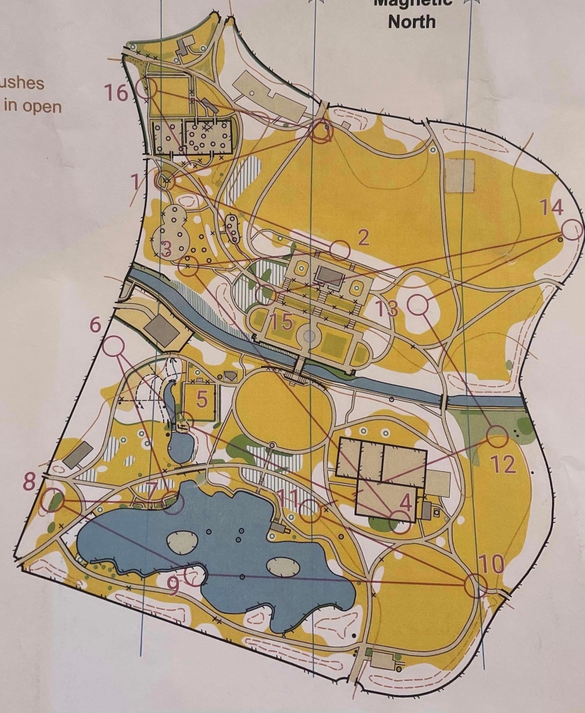
So, let my start by saying what a lovely course it was. The park was stunning & the way the course had been mapped led to a couple of interesting route choices.
My run started really well. The first leg was nothing out of the ordinary, a nice downhill run across a couple of paths to a bench feature at the bottom. I only mention it as I was amazed to find on the results later in the day that I was the quickest to the first control out of all the people on my course. For most people this will seem like nothing special, but trust me when I say I’m really happy with it.
The next couple of legs were reasonably straightforward. 3-4 gave the small route choice of which bridge to use over the canal, however I decided the time lost using the stairs would be better than running further to the second bridge. I think I made the correct decision here.
Control 5 was in a really good location. Set on top of a small mound, with a vertical slope to your left as you approached. The sudden steep slope up to the control certainly caught me out (as did the child who appeared through the hedge chasing his football & almost barrelled into me!).
Control 6 completely threw me. Marked as a copse, I took a bearing off the path and headed for the boundary fence. However I was surrounded by 4-5 distinct trees. The control was placed underneath the bows of a weeping conifer. Surely one tree doesn’t make up a copse? Don’t worry that’s my only gripe about the map.
The next few controls around the lake were nice and straight forward. However on my arrival at control 12, I decided to carry straight on through the woodland to the side of the canal & then follow the parallel path back to the bridge. At the time this seemed like the correct route to save doubling back, however i now am unsure as to which would have been quicker.
Controls 13 & 14 followed without a hitch. I wish the same could be said about my route to control 15. This was my one major navigation error on the course. Upon leaving the control I ran straight back across the grass, however cut through the copse which control 13 was set in. This bought me out on the wrong terrace in the formal gardens. In my head at the time I knew I needed to decent 1 flight of stairs, but in doing so was now 1 level too low for the control. I should have realised my mistake as I ran past the circular bandstand however continued to the far corner of the formal gardens. I only realised my mistake when I came found the corner of the undergrowth and found myself far too close to the canal. It was at this point I was able to relocate to the correct location. This whole error cost me around 45 seconds.
The run to control 16 was uneventful, however fatigue was setting in now and I struggled on the final leg up the hill to the finish. Ultimately this slow final leg cost me third place and I ended up finishing 4th. Below are my timing splits for each leg.

In conclusion then, this was a really good run for my first time back. It shows that I am still good at my navigation and my fitness is certainly coming. The next time I venture out orienteering I will try and do it on a slightly more complex area to see how I cope with that.
https://www.potoc.co.uk/index.php/results
To see my route, follow the route gadget link and it is self explanatory from there.
I hope that you have all enjoyed this write up. I will continue this series for every run I do. Until the next time, see you later!
