It’s great when things fall into place. Every year I attend the FA Vase final at Wembley Stadium. I normally head down to London for the weekend just to give myself a chance to explore somewhere new (and do a different Parkrun). This year I made plans to meet up with Peter Dudley after I had done the Parkrun. He had very kindly sourced this beer so I think it’s time to try it!
George’s – Cockleboaters Best Bitter
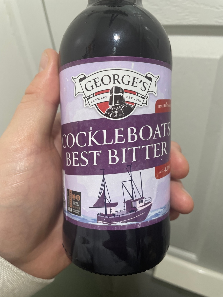
This 4%, 500ml bottle cost £4. A big Thankyou to Pete Dudley who was able to locate it for me!
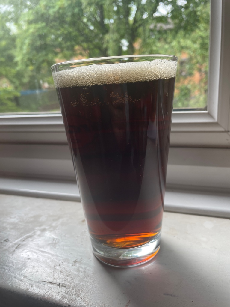
A proper best bitter! Sweet, malty but with a burnt aftertaste. There is almost the slightest hint of a plum taste too which is rather refreshing. The bottle tells me this beer was brewed by combining 5 malts & 2 hops but, without going into detail it’s impossible to guess which ones have been used. I am really impressed with this traditional bitter. It’s a dying style of brewing with the traditional market these days being replaced with either double digit percentage imperial stouts or huge mouthbombing ipa/dipa’s. To find a beer which sticks to the roots of brewing and doesn’t mess around with the basics is very special in my book. Head retention for this beer is excellent & carbonisation Is superb. It certainly adds to the overall mouthfeel of this beer. I’m really impressed.
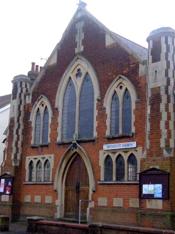
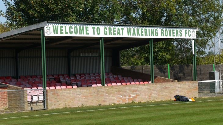
The brewery is based in Great Wakering. It is approximately four miles east of Southend. The village is well served with several historic public houses, a primary school, a Co-operative supermarket, post office, hairdresser’s and several small and characterful village shops. Great Wakering consists mainly of two roads: the High Street, which runs from the junction of Star Lane, and New Road, which begins outside St. Nicholas’ Parish Church and runs down to the bridges for Foulness Island. According to a medieval tradition, Great Wakering was the site of a monastery during the seventh century AD. Two Christian cousins of King Ecgberht of Kent, named Æthelred and Æthelberht, were murdered at Eastry, a royal dwelling in the Kingdom of Kent, during King Ecgberht’s reign (664–673). They were prevented by a miracle from being buried at Canterbury, and were taken instead to an existing monastery at Wakering in the Kingdom of Essex and enshrined there as saints. Ecgberht’s brother and successor, King Hlothhere of Kent, is said by William of Malmesbury to have ridiculed the idea of their sanctity. The village church, dedicated to St. Nicholas, dates back to Norman times and the board of rectors or vicars inside begins in the year 1200 with simply “Robert”, and the next incumbent equally simply named “Peter”. As well as the parish church, the village also has a United Reformed Church in Chapel Lane, a Methodist church, and an Evangelical church on Great Wakering High Street. Great Wakering is a village steeped in history. It has many community links to the Ministry of Defence-governed Foulness Island. The village was badly hit during the 1953 floods and locals fear a re-occurrence of the devastation now that tidal levels are rising and flood defences eroding. Of architectural interest is an old brickworks site (now partly demolished) at Star Lane, which was once served by an industrial narrow-gauge railway, the remains of which can still be seen in the bushes if you look carefully. Brick-making was once the main industry in Wakering. The factory finally closed in 1991, but the four towers remained a focal point on the horizon until September 2007, when the towers were finally demolished. In 2016, planning permission was granted to build new housing on the site. Much of the land area around Great Wakering is closed to the public as it forms part of a Ministry of Defence (MOD) firing range – the “New Ranges”. When firing is not taking place, however, the MOD beach at Wakering Stairs can be accessed via a rough road at Landwick security check-in. You can also cross MOD land and walk across the range from Cupid’s Corner to follow a muddy track to the seawall which offers great views over the Maplin Sands. The MOD beach is a great spot for watching Brent geese and waders. You will find much military debris around the area such as old firing targets, railway tracks, a lookout tower and several ruined batteries. There is also access here to the tidal path The Broomway, which leads to Fisherman’s Head on Foulness Island.
Fairfax Saxons FC are a Great Wakering-based football club set up to raise awareness of men’s health and to promote the community and local businesses via the medium of football. They play in the Southend Borough Combination Veterans League. This covers the Southend and surrounding areas. Home games are played at The Wakering Recreation Ground. It is a Sunday League set up. As a club, they train every Tuesday and on Sunday when there is no game on. They are always welcoming new players and we hope to expand to create more teams within the club. Great Wakering Rovers Football Club are members of the Isthmian League North Division and play at Burroughs Park. The club was formed in 1919 by soldiers demobbed after World War I and finding employment in the local brickfields. They joined the Southend & District League, dominating it during the 1960s and 1970s. In 1982 they switched to the newly-formed Southend & District Alliance Football League, but this league folded in 1989. At this point the club decided to make the step up to intermediate level and were founder members of the new Division Three of Essex Intermediate League. In 1990–91 Great Wakering were Division Three champions, earning promotion to Division Two. After winning Division Two the following season, the club successfully applied to join the Essex Senior League. They went on to win the league in 1994–95 and finished as runners-up three times in the next two seasons. They were as runners-up again in 1998–99, but as champions Saffron Walden Town failed to meet the ground grading requirements for a place in Division Three of the Isthmian League, Great Wakering were promoted in their place. The 1999–2000 season saw Great Wakering finish as runners-up in Division Three, earning promotion to Division Two. League restructuring resulted in them being moved to Division One North in 2002, and in 2004 they were transferred to the Eastern Division of the Southern League, where they remained for two seasons before being transferred back to Division One North of the Isthmian League. In 2011–12 the club finished bottom of the division, and were relegated back to the Essex Senior League. In 2013–14 the club were Essex Senior League champions and were promoted back to the Isthmian League. After finishing bottom of the division in 2016–17, the club were relegated to the Essex Senior League. However, they went on to win the league at the first attempt, earning promotion back to the renamed North Division of the Isthmian League. In 1985 the club obtained a lease from the parish council on a disused allotment site. A football ground was built by volunteers with the help of local farmer and supporter Roger Burroughs, who it was named after. The ground opened in 1989, with work starting on the main stand (the North Stand) in 1992, at which time a small covered area was built on the other side of the pitch. A roof was put on the main stand in 1996 and 175 seats later installed. A new covered terrace was installed in 2000. The North Stand was also expanded and currently seats 250.
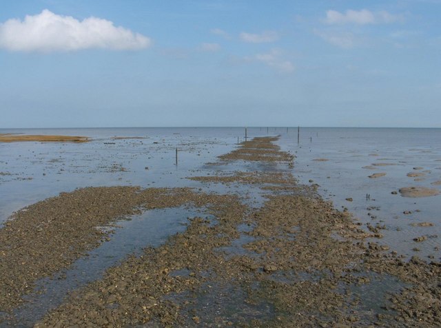
The Broomway, also formerly called the “Broom Road”, is a public right of way over the foreshore at Maplin Sands. Most of the route is classed as a byway open to all traffic, with a shorter section of bridleway. When the tide is out, it provides access to Foulness Island, and indeed was the only access to Foulness on foot, and the only access at low tide, until a road bridge was built over Havengore Creek in 1922. At over 600 years old, recorded as early as 1419, the Broomway runs for 6 miles along the Maplin Sands, some 440 yards from the present shoreline. It was named for the “brooms”, bundles of twigs attached to short poles, with which the route was once marked. A number of headways or hards ran from the track to the shore, giving access to local farms. The track is extremely dangerous in misty weather, as the incoming tide floods across the sands at high speed, and the water forms whirlpools because of flows from the River Crouch and River Roach. Under such conditions, the direction of the shore cannot be determined. After the road bridge was opened in 1922, the Broomway ceased to be used, except by the military. There is some disagreement over whether the main route is natural, simply following a ridge of firmer sand, or originated partly or wholly as a man-made track. Traces of Roman settlement on Foulness have been taken as evidence of a Roman origin, and it has been suggested that the track and its feeders were originally a road serving an agricultural area that was subsequently flooded. It has also been surmised to be an Anglo-Saxon era drove route, again subsequently inundated due to coastal erosion or 14th century storm surges but maintained using local knowledge and temporary waymarks. An archaeological survey towards the southern end of the Broomway revealed that it had, at least on that section, been reinforced with wooden hurdle work at some point. Noted in 1419, the route was mentioned in the following century by William Harrison in the Chronicles of Holinshed, who said that a man could ride to Foulness “if he be skilful of the causie [causeway]”. The Broomway was shown in some detail, along a route very similar to the present-day one, by the surveyor John Norden in a 1595 map. During the 18th century various efforts were made to improve the track, which was the main route from the island for farmers taking produce to market. In 1769, a guidebook stated that “the passage into is at low water, and on horseback, insomuch that many, either in negligence, or being in liquor, have been overtaken by the tide and drowned”. In the mid-19th century subscriptions were raised to reinstate Wakering Stairs, which provided a better southern point of access. The Broomway was formerly marked by a series of markers resembling short-handled besoms or brooms, hence its name. The “brooms” were driven two feet into the sands, protruded about a foot above them, were positioned around 30 yards apart, and were stayed with wire shrouds. The author Herbert W. Tompkins, who walked the Broomway in the early 1900s, described how as the tide ebbed the brooms would “lift their heads and appear as a line of black dots”, providing an indication of when the traveller might start their journey. The “brooms” required regular maintenance and replacement due to the effects of tides and storms: since at least the 18th century, this had been funded by a regular payment split between the parish and the island’s major landowner. The headways, at least in later years, were marked with fingerposts of the type then found on conventional roads, also driven into the sand. At night, when the “brooms” could be harder to spot, locals were accustomed to use the lights of the Nore, Mouse, and Swin lightvessels and the Maplin lighthouse to help judge their position. Often compared to the similarly dangerous path across Morecambe Bay, the Broomway has long been notorious as “the most perilous byway in England”. It has earned this reputation by virtue of the disorienting nature of its environment in poor visibility, and near inevitability of death by drowning for anyone still out on the sands when the tide comes in. Many people have died on it over the years. Writing in 1867, the Rochford historian Philip Benton described the risks for those without a guide, and said that others succumbed to the “pleasurable excitement” of the dangers: “some farmers would stay to the last, and then race the tide, and swim the creeks. Some of those who have been used to the sands all their lives have there yielded up their breath, and many hair-breadth escapes are recorded”. Benton recorded the deaths of, amongst others, Thomas Jackson, a Rochford apothecary, in 1711; Thomas Miller, a surgeon, thrown from his horse in 1805; William Harvey, a shepherd who was thought to have drowned in 1857 after being led astray by a navigation light; and Mr. Gardner of Havengore, who became lost at night while returning along his own headway. Benton had himself become lost on the sands in fog while shooting, and only escaped with “timely assistance”. In addition to the tide, fog and the risk of being swept away crossing the creeks, there were many “holes” in the mud away from the main path, particularly near the creeks, in which unwary travellers might become trapped. Despite it being used daily by the district’s postmen, even experienced locals remained at risk on the Broomway: as recently as March 1917, one of the “leading farmer[s] on the island” was drowned one evening returning along the Broomway from Rochford Market. The Foulness Burial Register records 66 bodies recovered from the sands since 1600, with perhaps over 100 people having been drowned in total. The area Public Right of Way Officer’s advice is that the Broomway should only be walked with a local guide. The Broomway leaves the mainland at Wakering Stairs, where there is a causeway over the band of soft mud (known as the Black Grounds or blackgrounds) which separates the mainland from the firmer ground of the Maplin Sands. Once upon the Maplin Sands, the Broomway heads approximately 60 degrees (magnetic) towards a navigation beacon known as “the Maypole”. This beacon marks the entrance to Havengore Creek. Beyond this point, travellers once had to also wade across the mouths of New England Creek and then Shelford Creek, until both were dammed in the 1920s. From the Maypole the road takes a more northerly route of approximately 50 degrees to the causeway leading to Asplins Head, the first of the surviving highways onto Foulness Island. From Wakering Stairs to Asplins Head is a walk of about one hour.
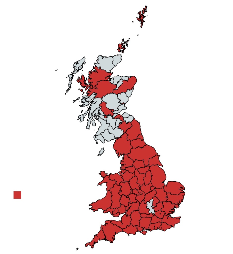
I cannot explain to you how exciting it is to have just 2 English counties left to do. It’s even more exciting when you factor in that one of the remaining 2 is currently impossible to complete so realistically I have one county left. If everything goes to plan on the day I publish this blog, I should be putting the groundwork in to complete England the following week. So all being well I hope that you will join me next week as we tick off England!